Monday, September 5, 2011

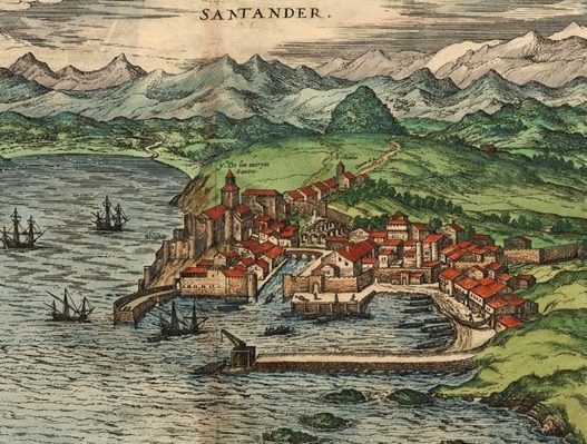
Santander - September 3rd & 4th, 2011

 http://upload.wikimedia.org/wikipedia/commons/0/09/Santcivitatis.jpg


                                        Santander, circa 1590 - by Joris Hoefnagel


The original plan (somewhat grandiose, it turns out) was that we would walk from San Sebastian to Santander, but this became impossible both due to the stages being long and difficult (at least for me), and Sergio needing to return earlier than expected to Málaga. So, we decided to skip the walk and take the train (a beautiful three hour journey) to Santander where we spent the last two days of our abbreviated Camino del Norte trip. Santander is located on the edge of the "Mar Cantábrico" and, for me, is highly reminiscent of childhood trips to Atlantic City (before it was destroyed by gambling industry, etc.).   We had cool, cloudy weather, a bit of rain, and generally spent the two days exploring the coast.   On the first evening, we took a tourist trip around the bay, and learned about the various important architectural sites: the former summer home of Spain's Royal Family (Palacio de la Magdalena), the Lighthouse of Cabo Mayor  which presides over the entrance to the Bay of Santander, and the beach of Sardinero.  Sardinero is lined with hotels, restaurants, and a casino, and is regarded as one of the most elegant beach resorts in Spain.


The port city of Santander is the capital of the autonomous community and historical region of Cantabria situated on the north coast of Spain.   In the early 1900s Santander became the favored summer residence of King Alfonso XIII, who built the Palacio de la Magdelena as the residence of the royal family during the holidays. The city gained great popularity from this and from the 19th century enthusiasm for sea bathing and it remains popular with the Spanish for beach holidays today.


                               Rocky coastline of Santander.


 One of the many varieties of signposts ("señales") guiding the Camino Pilgrims ("Peregrinos"), all of which include the yellow arrow ("flecha") and the symbol of the scallop.  The scallop shell, often found on the shores in Galicia, has long been the symbol of the Camino de Santiago.  Over the centuries the scallop shell has taken on mythical, metaphorical and practical meanings, even if its relevance may actually derive from the desire of pilgrims to take home a souvenir.  The scallop shell represents many different ideas associated with the Camino: One story says that after James' death, his disciples shipped his body to the Iberian Peninsula to be buried in what is now Santiago.  Off the coast of Spain a heavy storm hit the ship, and the body was lost to the ocean.  After some time, however, the body washed ashore undamaged, covered in scallops.  In another metaphorical meaning, the grooves in the shell, which come together at a single point, represent the various routes pilgrims traveled, eventually arriving at a single destination: the tomb of James in Santiago de Compostela.  The shell is also a metaphor for the pilgrim.  As the waves of the ocean wash scallop shells up on the shores of Galicia, God's hand also guided the pilgrims to Santiago


      A sculpture on the boardwalk of Santander designed from layers of oxidized iron, each with carved-out portions which, all together & viewed from a particular angle, create the face of a man.  There were a number of somewhat strange art sculptures around the city of Santander, including the following one which was high up on a cliff overhanging the sea:


The beaches of the city were alive with a multitude of sea creatures, birds, fish & even the sand itself looked to be the graveyard of many of these same animals:


                           A lone sea anemone in beach tidepool.


                           A baby coral in Santander tidepool.


                        Two sections of a seaside mural.


                         A bittersweet farewell to the Camino.

Decidimos acabar este Camino en Santander, para ello tomamos en Bilbao el FEVE, siglas que corresponden a Ferrocariles Españoles de Vía Estrecha. Estos trenes circulan por unas vías mas estrechas que el resto de trenes. Este tren discurre por toda la costa Cantábrica y es una forma ideal de conocer esta zona.

Llegamos a Santander después de tres horas de recorrido por entre frondosas montañas, oscuros túneles, por entre encajonados trayectos y pueblos pequeños.
Santander es una hermosa ciudad costera bañada por el Cantábrico. Nada mas llegar nos subimos en un barco turistico que hace una ruta por la bahia, que resulto ser muy instructiva, gracias a los comentarios que hacia el navegante, al mismo tiempo que gobernaba la embarcación.

A la mañana siguiente paseamos hasta el palacio de La Magdalena, un fastuoso palacio donado por el pueblo de Santander a Alfonso XIII, abuelo el actual rey de España.
Santander posee playas de amarilla y fina arena. Las mareas de este mar Cantábrico son significativas, y pueden llegar a dejar varadas a las embarcaciones. También dejan al descubierto infinidad de conchas y caracolas. Un lugar ideal para dejar descansar nuestros castigados pies...


            Dusty curioseando por entre las rocas que la marea dejo al descubierto.


Lezama to Bilbao - September 1st & 2nd, 2011


Fortunately, this was a short walk (11.79 kms.) as it was hot, humid, and apparently all uphill. Although this was certainly not one of the hardest walks, it offered little in the way of interesting vistas & at one point, I sent Sergio a text saying simply "estoy muriendo" ("I am dying") as I thought I might not make it up the incline. However, the arrival in the beautiful and fascinating city of Bilbao made the torture worthwhile.


We had decided to spend an extra day in Bilbao, both to visit the Guggenheim Museum there as well as to connect with a chico that I had met the night I encountered Sergio: Nacho. I will let Sergio write about our night out on the town eating tapas, etc.

The Guggenheim was simply fantastic: all of the exhibits were extremely captivating and thought-provoking. I kept thinking that I had never been so impressed by or engrossed in an art museum. They employ a great audio guide system where, in addition to learning about Frank Gehry's process of designing the incredible space that is the Guggenheim, each of the artists displayed discuss the thinking behind their work.

The curves on the building were to appear random. The architect said that "the randomness of the curves are designed to catch the light". When it was opened to the public in 1997, it was immediately hailed as one of the world's most spectacular buildings in the style of Deconstructivism, although Gehry does not associate himself with that architectural movement. Architect Phillip Johnson called it "the greatest building of our time".  Computer simulations of the building's structure made it feasible to build shapes that architects of earlier eras would have found nearly impossible to construct.

The collections usually highlight avant-garde art, 20th century abstraction, and non-objective art.


The famous sculpture of flowers that stands at the museum entrance known simply as "Puppy".


                  Windows reflecting the architecture surrounding the museum.


                      Sergio getting caught up in work while on vacation.


A photo of one of the exhibits where the artist is using LED technology to communicate words related to love and connectedness.

One of the exhibits that (as a psychologist) I found most interesting was a room full of televisions, each with a comfortable chair, with each screen showing a different person from Bosnia "telling their story".  It seemed that the idea was to demonstrate how the telling of one's story and making of a narrative is an intimate process that requires a "listener" who shares in the process.

El camino de hoy es explosivo, tras un pequeño recorrido de unos cuatro kilómetros llegamos a Zamudio, donde se encuentra la Torre de Malpica, donde en un expositor te explican las costumbres de la época medieval, su gastronomía y costumbres, junto a la iglesia de Santa María.
Pasamos junto a una zona industrial y de repente comenzamos una empinada subida hacia el monte Avril, con otra vertiginosa bajada con una espectacular panorámica de Bilbao. Demasiado calor por el camino y la humedad que se evapora del terreno se puede masticar.
Bilbao, nos recibe por su casco viejo, el cual ya solo abandonaremos para ir al museo Guggenheim.


Este llama poderosamente la atención desde la distancia, gracias a sus sinuosas formas en placas de titanio, como si de escamas de pescado se tratasen, según parece ser al arquitecto de tan caprichoso diseño le recordaban a las carpas que de pequeño echaban a la bañera tras volver con ellas del mercado. El interior es un derroche de imaginación de formas curvas, en el que casi las rectas no existen. Curiosamente el arquitecto hizo un boceto en un sobre el propio hotel cercano a la zona donde posteriormente se construyo este impresionante museo. Alberga obras, con las que los visitantes pueden interactuar con ellas.


http://upload.wikimedia.org/wikipedia/commons/1/11/Richard_Serra-The_Matter_of_Time.jpg
The Matter of Time, a series of weathering steel sculptures designed by Richard Serra and housed in the 430-foot (130 m) Arcelor Gallery (formerly known as the Fish Gallery). (photo courtesy of Wikipedia).  Por ejemplo hay una elipses deformadas en las que al caminar por ellas la sensación de mareo y desorientación es normal. Están construidas de unas enormes planchas de acero de cinco centímetros, que se dejaron oxidar en el exterior para dar diferentes tonos y curiosas texturas.


                               Dusty reflejada un tulipán.

Tulipanes


                         Sergio's contribution to the Guggenheim Collection.                    

 Sin embargo hay otras que desde mi punto de vista son autenticas estupideces. Nunca imagine que los escombros y retos de obras recogidas de los vertederos pudiesen considerarse por si mismas obras de arte... ¡Venga ya! estructura de carton yeso retorcidos.

Bueno anoche llame a Natxo, un chaval bilbaíno que conocí el año pasado en el Camino de Santiago, que hizo parte del Camino en bici, y que al final realizamos algunas etapas juntos. y que con el que pase muy buenos ratos. Tuvimos sin lugar a dudas un buen anfitrión que nos llevo por los diferentes bares del casco antiguo, degustando pinchos y bebiendo vino Txakoli, por entre las llamadas sietes calles, que todas ellas desembocan en la ría. Acabamos bien entrada la noche y emplazando nuestra próxima reunión en Málaga.

I had a wonderful time sharing in a "pinchos tour" guided by Sergio's friend, Natxo (Nacho), whom I had met the previous year at the same time that Sergio and I first crossed paths.  We stayed out late, eating, drinking and listening to music until the early morning hours.

Posted using BlogPress from Dusty's iPad.

Gernika-Lezama - August 31, 2011

Hicimos noche en una modesta pensión de Gernika. Como siempre nos disponemos a ordenar y cerrar nuestras mochilas. Tras un breve desayuno emprendemos la marcha por entre la cuidad y buscando las flechas amarillas. Pronto dejamos la localidad y nos adentramos en el bosque y tras una prolongada y fuerte subida, nos situamos en el alto de Bill ikario, recreándonos con las maravillas vistas, reponemos fuerzas. Ahora en un constante sube y baja nos dirigimos a Goikoletxea, que para nuestra sorpresa, están de fiestas. Dusty como siempre pide agua con gas y limón y yo como siempre pido una cerveza muy fría. Conversamos animadamente y decidimos reanudar el camino hasta Lezama, pasando antes por Larrabetzu. Desde aquí el camino es bastante tedioso, ya que transcurre al arcén de la carretera Bi-2713. Andar por el arcén de la carretera es algo que no nos gusta, tan solo son tres kilómetros y medio. Temiendo
que el pequeño albergue este lleno como es costumbre, nos dirigimos hasta una casa rural, la casa Madarian. Emplazada en plena naturaleza, lejos del casco urbano es un oasis de paz y tranquilidad, si no fuese porque Dusty volvió a abrir la ventana de la habitación y en plena noche, se colaron los alados mosquitos como un ejercito en orden de combate... la batalla fue horrible, conseguí matar a mas de quince, e hice cuatro prisioneros en el cuarto de baño, que fueron ejecutados al amanecer... los rastros de sangre daban fe de la ferocidad de la batalla, en el techo, cortinas, paredes, suelo y junto a ellos, los cadáveres de los enemigos.
Ayer caminamos 21 kilómetros.


                          Amigos del Camino

Friday, September 2, 2011

Gernika - August 30. 2011

Hoy tan solo haremos seis kilómetros, la ciudad de Gernika merece especial atención, de manera que pasaremos aquí todo el día.
Cómo imaginar que en este cielo de un azul intenso, apoyado sobre montañas verdes, el 26 de Abril de 1937 la Legión Cóndor del ejército Alemán sembró de bombas la población de Gernika.

El general Mola al mando del ejercito del norte dicto un ultimátum y dijo: He decidido acabar con la guerra en el norte de España, todo aquel que no sea un asesino o combatiente o deponga sus armas será respetado en vida y haciendas. Y dispongo de los medios necesarios para ello.

Los alemanes a su vez querían probar su aviación y este tipo de bombardeos, y de que también sus pilotos adquirieran experiencia...
El 26 de Abril a las 16:30 de 1937 sonaban las campanas de la iglesia de Santa María, el cielo pronto se cubrió de aviones que descargaban sus bombas, primero bombas rompedoras sin carga explosiva y después bombas incendiarias. Teniendo en cuenta la arquitectura de entonces, las bombas de 250 kg penetraban en las casas como en la mantequilla y destruían las casas desde sus tejados para seguidamente rociarlas de bombas incendiarias. El efecto fue devastador, la ciudad quedo arrasada. Para peor de males, los cazas ametrallaban a la población que huía despavorida... de una población de 7000 personas, murieron 1600 y mas de 800 heridos... El horror de la guerra en su máxima expresión.

El general Mola hace entrada por el puente, que se suponía el objetivo militar, junto con las fabricas de bombas que tampoco son destruidas...
Para la exposición universal de Paris, el gobierno de la república encarga a Pablo Ruiz Picasso una obra y pinta el famoso cuadro de Guernica.


            Mural que representa el "Guernica" en las calles de la población.

En esta ciudad, también existe el árbol "sagrado", se trata de un roble.
Antiguamente cada anteiglesia enviaba a su representante a debatir los problemas comunes del señorío. Estas se llamaban juntas generales y se hacían junto a este árbol.
Hoy hay una casa de juntas y su árbol ha sido reemplazado en tres ocasiones por retoños de su antecesor.


                         Restos del tronco del árbol viejo 1742 / 1860.


Árbol nuevo hijo de los anteriores, junto a la fachada de la Casa de Juntas de Bizkaia.

Guernica is best known to those residing outside the Basque region as the scene of the April 26, 1937, Bombing of Guernica, one of the first aerial bombings by Nazi Germany's Luftwaff.   The Germans were attacking to support the efforts of Francisco Franco to overthrow the Basque Government and the Spanish Republican government. The town was devastated, although the Biscayan assembly and the Oak of Guernica survived. Pablo Picasso painted his famous "Guernica" painting to commemorate the horrors of the bombing.

All I really knew of the town of Guernica before spending the day at the Peace Museum  was that it had been bombed by Germany and was the subject of the famous painting of the same name by Picasso. The much more complicated story is that the city of Guernica was the legislative seat of the Basque country who were in conflict with Franco's Nationalists during the Spanish civil war.  Guernica represented an important strategic point because it was a haven for the Republicans (anti-fascists) and was in the way of Franco capturing Bilbao.  Franco enlisted the aid of both the Italian and German Fascists to destroy the town and it became a symbol of terrorist bombing: using the destruction of civilians in an effort to bring about the submission of a people. In 1997, on the 60th anniversary of the bombing, the German President, Herzog, made a formal apology to the Basque people for the destruction, and for Germany's role in the Spanish war in general.

Today, Guernica is the home of the fascinating Peace Museum which has exhibits relating to the importance of human rights around the world, tells the story of the Basque country struggle for independence as well as the destruction wreaked by both ETA (pro independence terrorist group) and the Spanish government's attempts to repress and destroy ETA. In the center of the city, there is also a ceramic copy of the famous painting.  Since the 19th century, the people of the Basque Country have been demanding some sort of independence, and this is particularly desired by the more left-leaning groups that are part of the political scene there.  ETA is recognized as a terrorist organization by the European Union and the United States.  In 2006, ETA declared a "permanent ceasefire" after nearly 40 years fighting for independence from Spanish and French authorities and the annexation of all Basque lands to a united, socialist state. In June 2007, ETA officially ended the "permanent ceasefire". Since then it has committed several bomb attacks and assassinations. In September 2010 ETA again announced a permanent cessation of violence.  At first the 2004 train bombings in Madrid were attributed to ETA, but it quickly became clear that they were part of an organized strategy of terror conducted by Bin Laden and his friends.


                                            The artist at work.


                                      One element of the painting.


Stained glass ceiling displaying the sacred tree that represents the Basque legislative/administrative body that was centered in Guernica.

Thursday, September 1, 2011

Markina a Mendeta - August 29, 2011

Gracias a la labor de los amigos del Camino disponemos de un pequeño albergue con capacidad para 28 peregrinos, esta ubicado en la parte trasera del convento de los Padres Carmelitas. En una estancia nos disponemos a descansar 12 personas repartidas en seis literas. El cansancio es denominador común entre nosotros, de alguna u otra forma, con mas o menos intensidad. Pronto nos convertimos en doce almas sumidas en un profundo sueño, entre jadeos y ronquidos amanece y hemos de abandonar el albergue.
Para el día de hoy hemos decidido hacer 17 km. hasta Mendata. El recorrido comienza suavemente para convertirse en una nueva y vertiginosa subida, pero antes hacemos una parada en Bol ibar (caserío de Errementarikua) esta pequeña población es la cuna de Simón Bolivar, que como todos sabemos fue el libertador de Venezuela. Y que posee un museo dedicado a Bolivar.
Dejamos esta localidad y comenzamos a subir por entre bosques de pinos y helechos hasta una calzada medieval que nos conduce al Monasterio de Cenazurra. Una obra arquitectónica de extraordinaria belleza. Su construcción en este lugar hace mil años se debe a una curiosa leyenda, en la que parece ser que un águila tomó una calavera de la ermita de Santa María de Garai en Gerrikaitz y la dejó caer en este lugar. en el siglo XV paso a ser Colegiata y en el 1994 paso a ser monasterio con la llegada de los monjes cistercienses. También posee un hermoso claustro renacentista.
Entre verdes y húmedos caminos llegamos a Mendeta. El albergue es confortable y amplio, hay camas de sobra y tras una reconfortante cena nos disponemos a descansar.


                        Población de Bol ibar


                               Calzada medieval hacia Cenarruza


                      monasterio de Cenazurra


                                  Claustro del mismo monasterio.


                                  Camino a Mendata.

Markina a Mendata - August 29, 2011

This was a fantastic day of walking under cloudy skies, cool weather and through the lush countryside covered with wildflowers. It was the Camino del Norte I had expected: challenging (7 hours with a break for lunch) but not so exhausting that I could not appreciate the scenery or the company.


                               Wildflowers everywhere.


                               Grape vine along the road.


                           Lone cyclist riding down the Camino road.

This cottage might be found in a fairytale: surrounded by flowers and nestled in the greenery.

If I had video capabilities, I would post a (probably funny, but possibly embarrassing) video of Sergio's impression of the reason that my walks are so long: adjusting my backpack, repeatedly tying my shoes, cleaning my sunglasses, fooling with my iPod, searching for sunscreen-- you get the idea. He is (probably correctly) convinced that, were I to just WALK, I would arrive significantly sooner and have fewer problems.  

Posted using BlogPress from Dusty's iPad.

Deba a Markina - August 28, 2011

I am going to let Sergio write about this stage which was (objectively) extremely difficult: only 21+ kilometers, but with constant steep inclines lasting for hours followed by equally steep slippery and muy peligroso descents.   I can say that I walked for 10 hours and was in a miserable mood when I arrived in Markina, certainly not fit for human interaction. Sergio's memory of the day was quite different: it was just the kind of challenge that he loves. As I keep reminding him, we are not exactly alike.


Hoy nos enfrentamos a uno de los días más duros de este Camino. La orografía del terreno va a jugar una mala pasada a nuestras castigadas piernas, son los llamados recorridos rompepiernas. Tras una interminable subida comienza un vaivén de subidas y bajadas, para terminar con un vertiginoso descenso, cuando menos delicado. Mas bien resbaladizo y hasta peligroso.

La salida del albergue de Deba hacia el inicio del Camino es peculiar, debemos tomar un ascensor por entre las calles que nos bajará a nivel del mar, nunca en mi vida había visto algo semejante.

Después de un sencillo desayuno en un bar cercano buscamos las flechas amarillas que nos sitúan en el camino... nada mas cruzar un puente sobre la ría comienza una empinada subida que no cesara hasta situarnos a quinientos metros sobre el nivel del mar. El paisaje reconforta el esfuerzo realizado, entre un verde exuberante y de naturaleza propia de una zona lluviosa, en la que la presencia del sol no es lo habitual aunque estamos en verano las lluvias en esta parte de España es habitual. Entre vacas pastoreando, ovejas y caseríos de formidable belleza llegamos a Olatz, una pequeña población situada en un pequeño valle en la que la población vive sus cultivos y del ganado, como zona rural que es. A las vista hay unas seis casas, pero tiene una pequeña iglesia y un bar, es aquí donde reponemos fuerzas para la peor parte del camino.

Entre esbeltos pinos de impresionante tamaño y helechos, junto a un pequeño arroyo, discurre una suave pista, que progresivamente se hará muy empinada. El esfuerzo para superar esta zona es considerable. Al final tienes una fuente de agua fresca, que antiguamente usaban las mujeres como lavadero. Una pequeña parada y tras unos cuatro kilómetros de pista recuperadora, comienza la abrupta bajada hasta Markina. A la entrada en este pueblo hay una hermosa hermita hexagonal de San Miguel de Arretxinaga del siglo XVIII, en su interior hay es grandes peñascos que se sujetan entre si, estos forman la capilla que ofrece culto a San Miguel. Es alrededor de estas piedras donde se construyo la hermita.

Suena es teléfono, Dusty llega buscándome en un estado lamentable. No habla, solamente farfulla. Esta agotada, lógicamente, la etapa ha sido devastadora... mañana será otro día. Así es el Camino, sufrido, doloroso y fascinante...

                            Landscape on the hard road to Markina.

Zumaia a Deba - August 27, 2011

This was a comparatively short day with beautiful views and the chance to get in early enough to download photos and for Sergio to write his more extensive descriptions of the first couple of days. I am including a couple of photos from the previous evening in Zumaia since they were not available at that time. We were able to see an incredible sunset on the other side of the small peninsula.


Deba itself is this town built on multiple levels with a central outdoor glass elevator that one takes to get from the heights down to the town center. There was some question as to whether there would be sufficient beds for all of the pilgrims & Sergio took responsibility for going to the Tourist Center to get a key to the rather stark albergue (seemed to have been a school in an earlier life) as (per usual), he had arrived earlier than I.  As we were sitting having lunch, he totally convinced me that there was not a bed to be had anywere: not at the albergue nor in any of the small hotels, and we were simply going to have to sleep on the beach.  So convinced was I that I spent time getting storekeepers to telephone various lodges to find us a room rather than sleep on the beach as he proposed. Fortunately, this was just his idea of fun. It was a relaxed and enjoyable day to be followed by the most difficult one (see next entry).

El requisito indispensable para hace uso de los albergues es presentar la credencial, que da crédito a tu estatus de peregrino. Debes seguir unas normas. A las diez de la noche cierran los albergues, algunos son un poco mas flexibles pero no es lo habitual, es lógico que después de un duro día caminando quieras descansar, ya que otra de las normas es abandonar el albergue a las ocho de la mañana.

La noche transcurre entre ronquidos y sonidos difíciles de identificar, creo que a veces no son humanos. En una habitación con mas de veinte almas sorprende de lo que somos capaces de interpretar sin haber estudiado solfeo.
Amanece sobre las siete y con la luz que se filtra entre las ventanas del convento de San José empezamos a desperezarnos a pesar de que nuestros cuerpo suplican un poco mas de descanso.

Salimos dirección a Itziar entre subidas y bajadas por pastos y pequeños caseríos como el de Elorriaga con su hermosa y pequeña y con su tejado atestado de gatos. Tras una pequeña subida comienza el descenso hasta Deba.

Es la segunda vez que estoy en Deba, hace casi treinta años que estuve aquí corriendo toros por las calles de este pueblo.

Las flechas amarillas del camino nos llevan hasta un ascensor... buscamos el albergue y visito la iglesia de Santa Maria la Real.

La estancia en el albergue es como siempre breve... Mañana tendremos uno de los días mas duros de este Camino.

Posted using BlogPress from Dusty's iPad.